supported data formats
vector formats
TopoL xT can directly read most common vector data formats. Some of them can be even edited.
vector data formats which TopoL xT can directly edit
- TopoL Block (native format)
- ArcView ShapeFile
- DGN
- DWG
- DXF
vector data formats which TopoL xT reads and can export them
- VYK (Kokeš, MISYS)
- MIF/MID and TAB of MapInfo
- relational database ORACLE
- relational database PostgreSQL with PostGIS extension
- relational database MS SQL by GDO (Intergraph Geomedia)
- relational database MS SQL with native support of spatial opperations
- Access MDB by GDO (Intergraph Geomedia)
- Access MDB ESRI Geodatabase (ESRI ArcGIS)
- Access MDB by TopoL
- Google Earth KML
vector data formats which TopoL xT can import
- points in any ASCII file / the user can define the meaning of the columns in ASCII file with a wizard
- Arc/Info Generate format
- VFK (new format of Czech cadastral maps)
- VTX, DKM, VKM (old format of Czech cadastral maps)
- VGI (format of Slovak cadastral maps)
- Polish
Google Earth
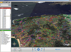
[TopoL xT can export vector data to KML 2.0 format for Google Earth and raster data KMZ format. Vector data in KML 2.0 can be displayed directly. Export into KMZ format can be used also for Garmin GPS.
Web Map Service (WMS) and Web Feature Service (WFS)
Web Map Service (WMS) and Web Feature Service (WFS) area basic services for data displaying on Internet. In case of WMS the raster data are generated by map servers and in case of WFS the vector objects in GML format. TopoL supports both of them.
raster formats
- TopoL RAS
- TIFF (including GeoTIFF and TIFF with JPEG compression)
- BMP
- CIT
- JPEG
- JPEG 2000
- GIF
- PCX
- HRF
- COT
- RGB
- RLE
- ECW
- MrSID
- PNG

