TopoL-L
TopoL-L is the application of TopoL xT and it is used for Forest Management Plans creation in Russian Federation.
This application was developed by Russian company LesIS. The architecture of this system is based on full interaction with TopoL xT. TopoL-L is multilevel information system. The user can work with high-level integrated data of forest fund inventory at federal or regional district levels or with detailed forest data on compartment and stratum levels. The system indicates witch data are really available in its database on any level. For all levels and all kind of operations it uses tools to search data and to manage data.
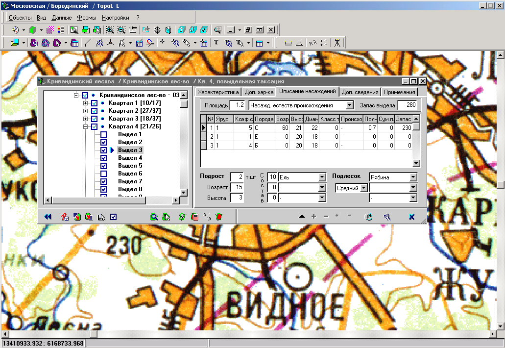
ukázka prostředí
programu TopoL-L
The main problem of development forestry information systems in Russia is large size of Russian territory, long distances between forest management units and forestry enterprises, deficit of experienced informatics in far parts of Russia. In this situation it is difficult to organize qualified user support “in place”. Training in LesIS or in forests inventory and management enterprise Lesproject, which has training center, is possible only as introduction to GIS technologies for the limited number of specialists. Taking this into consideration the task for LesIS was to develop the information system for Russian forestry, which can be learned by users themselves. The support of this training process is provided mainly using the Internet.
TopoL-L has got specialized user interface for the forestry part of system and for working with maps. Simple intuitive technologies for synchronized changing of data both in digital map and joined forest exploitation database are implemented. It is more useful for beginners of GIS-technologies. An experienced user can effectively use additional functionality of the system and more complex universal tools.
Forestry database window is fully resizable and may float on top of map window or it can be hidden during manipulating with map. This window includes two main panels. The left one always shows hierarchical tree of data district levels and data objects from Federal Forestry Management Service to small forest stratum. The right panel contains the data itself depending on object currently selected in left tree. Selected data set may be simply changed by clicking on the label of any object in tree. To make complex interactive tasks of synchronized changes of digital map and database the “wizard” (“expert”) interfaces are implemented.